
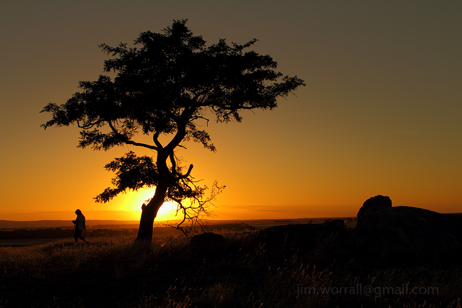
Reefton Vista
A sweeping vista viewed from Woods Point Road, near Reefton in the beautiful Yarra Ranges, Victoria.
With still another 6 weeks of COVID-19 lock-down to endure, it makes me truly appreciate the simple joy of being able to get out and immerse myself in photography.


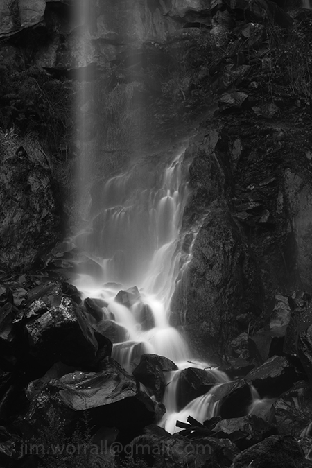
Sailors Falls
Sailors Falls is a beautiful spot just a few kilometres south of Daylesford on the Ballan-Daylesford Rd.
We were lucky enough to catch the falls with a decent flow of water going over the edge.
A Morning at Bushrangers Bay
Following are some long exposure images from Bushrangers Bay on the Mornington Peninsula.
The bay is accessible via a scenic walking track that begins at the Cape Schanck lighthouse carpark. Allow about an hour each way for the walk and make sure you carry some drinking water. There’s also an alternate walking track that goes from Boneo Road to Bushrangers Bay. Both tracks are about the same length.


New Fern Life – Sherbrooke Forest
A couple of images from a cool winter’s walk through Sherbrooke forest, Victoria, Australia.


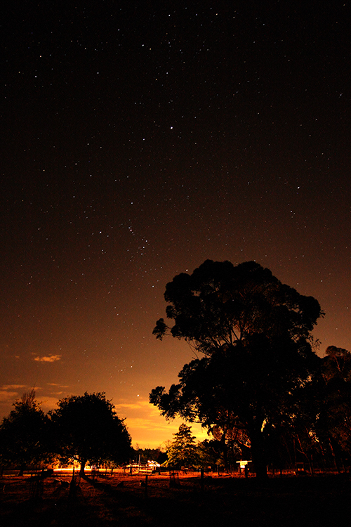
A Hot Starry Night at the Shed
An night time image from semi rural Devon Meadows. The foreground is lit by the long exposure picking up light from a neighbour’s house. Stars are apparent in the night sky.
Sunset at Dog Rocks, Batesford.
A sunset image taken at Dog Rocks, Batesford, Victoria, Australia. It was the 21st December 2012 which was supposedly meant to be our “last day on Earth”. Thankfully it was all hot air as expected. 😉
Olinda – Ferns in the Dappled Light
I went to shoot the Olinda Falls today but the light turned out to be a bit too patchy and harsh. The dappled light streaming down through the tree-top canopy did however provide the right conditions to make a feature of the ferns.


Thunder in the Air – Outdoor Dunny
This is an image I captured during an excursion through northern Victoria quite some time ago. At the time I didn’t bother to post it in my blog because I didn’t think there would be much interest in it.
Boy was I wrong, …this is currently one of the best selling images on my Zazzle site.
Who would of thunk it?

The Noojee – Toorongo Photo Trip
It was one of those spur of the moment decisions.
Chris and I took off for a leisurely drive intending to have lunch at the Noojee pub followed by an afternoon of shooting at the Noojee trestle bridge and the Toorongo River.
As it turned out things were very quiet in Noojee that Friday.
We entered the strangely vacant Noojee hotel dining room and spent a few minutes looking through the menu whilst hoping that they were actually open for business.
After a short time we were discovered by a helpful barmaid who ushered us into the bar area whilst explaining to us that the dining room was closed.
Pictured below – Dappled sunlight across the middle of the Noojee Trestle Bridge.

After being seated in the bar area Chris and I both chose the beer battered fish n’chips for lunch. Perhaps it wasn’t the most “heart smart” choice from the menu but it was indeed very tasty and satisfying without being too heavy. 🙂
As we ate our lunch Chris and I would occasionally glance over at the only other occupant of the room. One of the elderly locals was perched at the bar with beer in hand and kept nodding off to sleep. He appeared to be very skilled repeatedly awakening himself just prior to losing balance.
Pictured below – A shot taken from the top of the trestle bridge looking down on the access road. I’ve applied an Orton effect filter to this image to soften it a bit.

After finishing our delicious meals we visited the nearby Noojee trestle bridge. The light wasn’t particularly friendly that day as the morning clouds had dispersed causing a problem with harsh shadows and bright spots but we did our best.
Next stop was the wonderful Toorongo River. I always enjoy the scenic drive along the Toorongo Valley Road that leads to the falls.
It’s great to see the river with such a strong flow and healthy green mosses and small ferns growing on the moist rocks again.

During this trip I decided to try out the camera built into my phone and capture some images using an Android app called Retro Camera. It uses some interesting processing techniques to imitate old school cameras. A fun app!!
Pictured below – The Retro Camera interpretation of the Toorongo River.

Pictured below – A serene image from along the Toorongo Valley Road processed by the Retro Camera app.

Pictured below – Chris checking her shots on the banks of the river behind the Noojee pub.
Image processed by the Retro Camera app.

Visiting the Silky Lady – Hopetoun Falls
The Hopetoun Falls is a popular tourist attraction located in the Otway Ranges in Victoria, Australia.
Pictured below – A View to the Falls – Just a short distance from the car park, visitors are treated to a tempting glimpse of the falls from above through a gap in the lush forest greenery.

A short picturesque walk down a path through the forest gives access to the base of the falls. Upon arrival at the base it’s very easy to imagine that you’d somehow been transported into a fairytale. It’s a dream location for photographers and indeed it’s difficult to take a bad shot here.
Below – The Silky Lady

Below – Peeking at the Silky Lady

Below – In the Land of Fairytales

Abandoned, dilapidated, derelict, decayed and once loved.
Following is a collection of farmhouse images taken on a trip through western Victoria and South Australia.
Initially I intended to take a lot of seascape images on this trip but the rain and sheer cliffs along the Great Ocean Road often conspired against me.
As the journey progressed I found myself becoming more interested in the landscape including the many vacant derelict buildings scattered along the way.
Below – “Shambles” – A deserted farmhouse at Byaduk North, Victoria, Australia.

Below – “Out the Back” Byaduk North, Victoria, Australia.

Below – “The Love Shack” – Found along the road north of Port Fairy, Victoria, Australia.
There is also a colour version of the Love Shack here.

Below – “Spiders n’ Snakes” – an abandoned house along the roadside in Puralka, Victoria, Australia.

Below – “Cottage in the Vineyard” Padthaway Heritage Cottage (Front) near Bordertown, South Australia.

Below – “Backdoor to the Vineyard” Padthaway Heritage Cottage (Rear) overlooking the vineyard, near Bordertown, South Australia.

Trestle Bridge Encounters.
Whilst on a recent photography tour of eastern Victoria I encountered a couple of old wooden trestle railway bridges, …….and who can resist a good bridge!

The Stony Creek trestle bridge (pictured above) is located at Nowa Nowa in Victoria’s south east.
Apparently this is the largest standing bridge of it’s kind in Victoria, measuring 247 meters long and standing 20 meters high. The bridge was made in 1916 and remained in service for over 60 years until it was damaged by bushfire in 1980.
– – – – – – – – – – – – – – – – – – – – – – – – – – – –
The two images below were taken at the trestle bridge in Mt Lawson state park, in Victoria’s north east.
The high timber bridge which was built around 1915 spans Boggy Creek and formed part of the now disused Wodonga – Cudgewa railway line.
The view from above –

The view from below –

Exploring Cement Creek
It seems to me that Cement Creek was dealt an injustice when it was first named.
Despite it’s odd name, it really is quite an attractive location and a fine example of lush Victorian forest.
Cement Creek in located at the foot of Mount Donna Buang, near the intersection of Donna Buang Rd and Acheron Way.
On this excursion we gained access to the creek by walking along raised platforms which got us most of the way, then we jumped the handrail into the forest to get to the flowing water. At this location you need to be prepared to get muddy and wet, so it’s advisable to keep a change of clothes in the boot of your car.
The main hazard here is the slippery moss covered rocks. A minor hazard is the hungry leeches.


Burrabong meets the Bushranger
This image shows the Burrabong Creek meeting the ocean at Bushrangers Bay near Cape Schanck, Victoria.
Bushrangers Bay is a secluded beach located about one hours walk from the Cape Schanck car park.
The walking track winds it’s way through beach scrub, up and down hills including many stairs, and along scenic clifftops.
I would advise anyone taking this track to wear sturdy footwear as the path is shared with aggressive bull ants for much of the way, and of course there’s always a chance of encountering a snake sunning itself. Oh, and don’t forget a bottle of drinking water.

The Edge
Gum trees growing precariously close to a cliff edge in western Victoria, Australia.
I was attracted to this scene by the trees silhouetted against the bright cloudy sky and of course the dead limbs in the foreground.

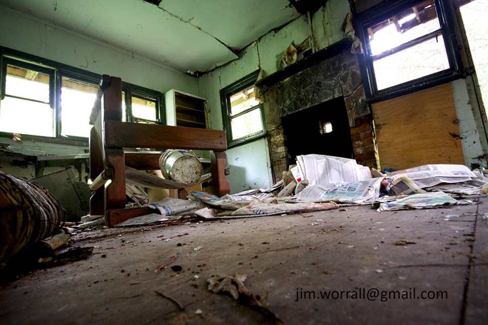
Home Sweet Hell
Images from an abandoned house taken during an excursion to the Dandenong Ranges, Victoria, Australia.

The image above is available to purchase as a print here.


Through the Fingal Forest
These images were taken on a recent excursion to Fingal beach, near Cape Schanck, Victoria, Australia.
The long track from the carpark to the beach is lined with twisted and gnarled trees creating an interesting viewing experience.
Visitors to the beach also experience the joy of navigating the hundreds of “awkwardly spaced” steps along the path. It’s not so bad going down to the beach but the return uphill journey is certainly a good test of your general fitness. Of course the ideal solution is to take along a strong, sturdy friend who can carry you back up the hill.
The images below were all taken using the Lumix LX3 camera.


After traversing the Fingal forest I managed to take this image.
Roadside Falls
A small waterfall by the road somewhere south of Woods Point in hillbilly country, Victoria, Australia.
Roadside Falls

Morning in the Forest of Ferns
Early morning in the forest of ferns.
As the sun rises higher in the sky, beams of sunlight break through the forest canopy spotlighting details in the foliage.
Glint


Remnants – a visit to Walhalla cemetery
Graves from the late 1800’s on the sloping grounds of Walhalla cemetery.
Remnants – Walhalla cemetery

Pictured below – The unusual grave of Elizabeth A. Holmes (aged 20 years) and Mary A. Holmes (aged 10 months) who passed away in the 1870’s in Walhalla, Victoria, Australia.
A reflection of tougher times.
Resting Place – Walhalla

Pictured below – Looking down the sloping grounds of the Walhalla cemetery towards the main road below.
On the slopes of Walhalla


