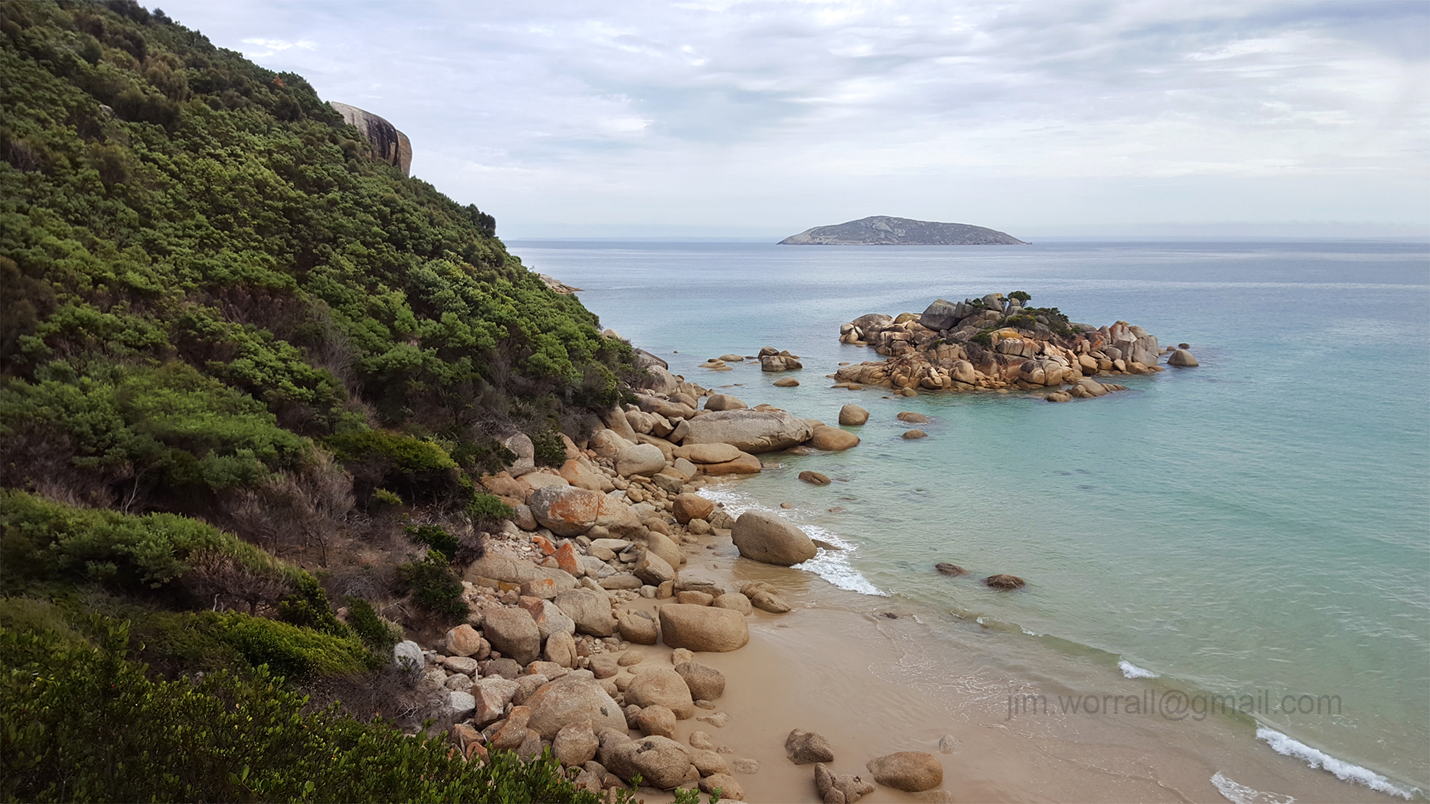
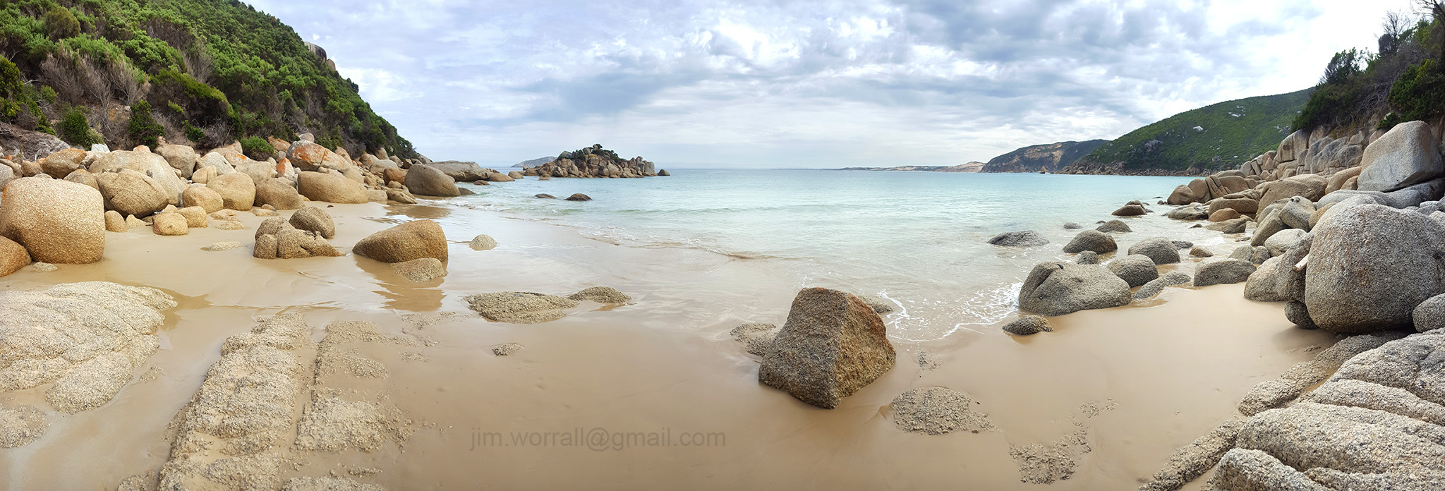
Fairy Cove – Wilsons Promontory
Fairy Cove is a secluded beach on the beautiful Wilsons Promontory. Access to Fairy Cove is via a signposted diversion off the Darby River to Tongue Point walking track. The cove features large rounded granite boulders, clear water and beautiful scenic surroundings. The cove is best visited at low tide for beach access.
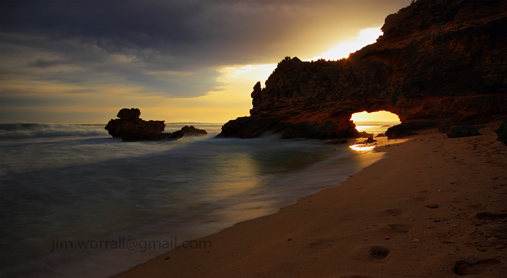
The Trek to Bushrangers Bay Arch
There are two public walking tracks into Bushrangers Bay that are about the same length. One track starts north-east of the bay at Boneo Road and the other track begins at the Cape Schanck lighthouse carpark, west of the bay.
We chose to walk the track from the Cape Schanck lighthouse carpark because it’s arguably more scenic and there’s a lot more carpark spaces available.
Along the sandy track there’s a couple of opportunities to look back along the coastline towards Pulpit Rock.

Further along the track the native trees enclose the path and form a welcoming tunnel.


After a bit of walking the bush track crosses the Burrabong Creek via a small wooden footbridge. Eventually the bush track opens onto the sandy beach of Bushrangers Bay. Here you’ll encounter Main Creek which cuts through the sandy beach and enters the ocean.
You need to cross the creek. You might get wet feet here depending on how much water is flowing in the creek at the time, and how far you can jump. 🙂
In the photo below, Main Creek cuts through the sandy beach on it’s way to the ocean.

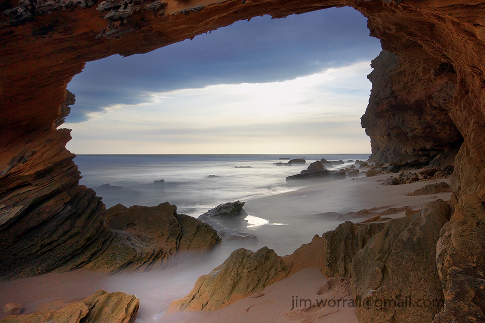
After crossing the creek it’s a short walk to the beautiful rock formations and platforms where at low tide there are lots of small crystal clear rock pools exposed.


At the water’s edge the rock platforms rumble as waves slam into the steep rocky walls.


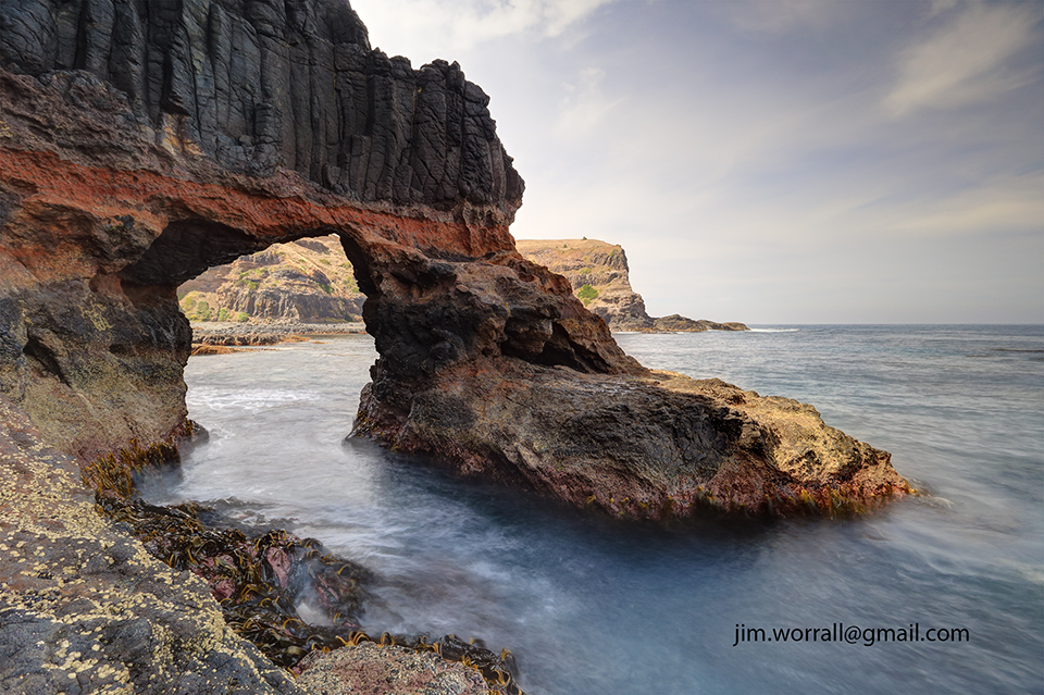
Looking back from the arch towards Bushrangers Bay, lots of people exploring the platforms and rockpools.
It was a public holiday and very busy.


When we arrived at the arch we found that much of it was in the shade with very bright background elements.
This is problematic from a photography perspective, but anyway you work with what you’re given. 🙂

Photo below – Using a nice wide lens, some ND filtering, and blending 3 exposures I ended up with a keeper that I like.
This image is available to purchase as a print here.

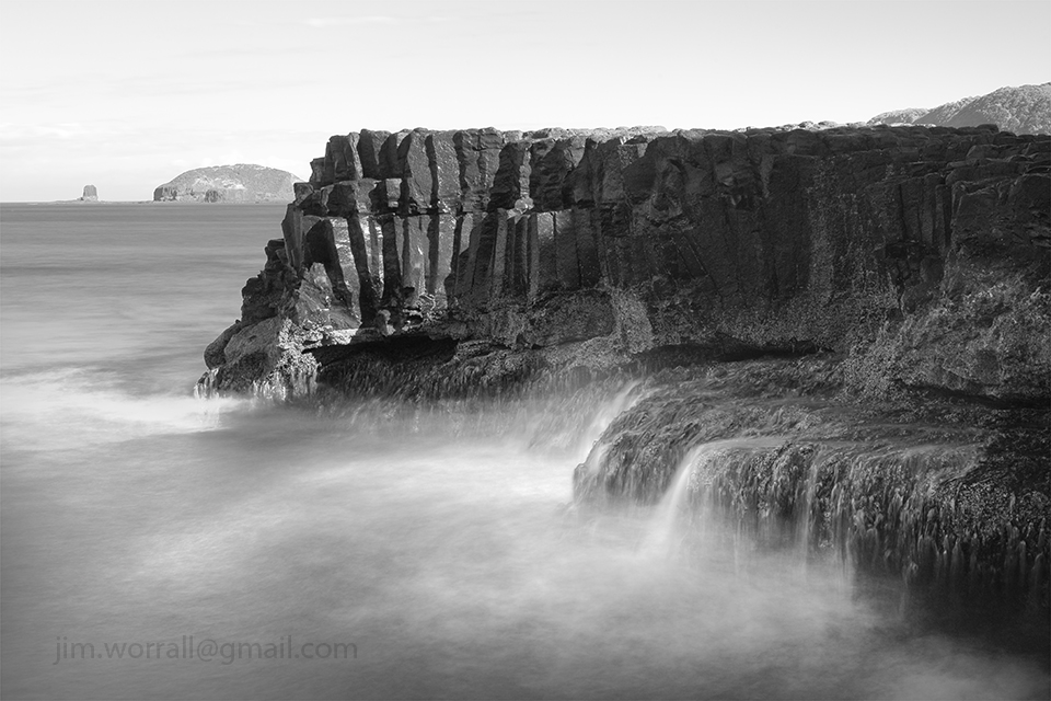
Bushrangers Bay – The Splash Zone
The “splash zone” at Bushrangers Bay, near Cape Schanck on the Mornington Peninsula.
Tech stuff – 15 secs f/14 ISO100 with an ND400 filter
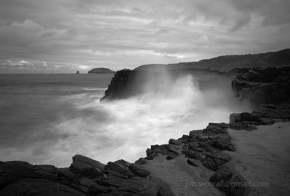
Bushrangers Bay – The Boiling Ocean
Following are some images from an excursion to the wild coastline at Bushrangers Bay on the Mornington Peninsula.
I highly recommend the 3km hike from the carpark at Cape Schanck lighthouse to Bushrangers Bay. The scenic track follows the coastline along clifftops and through bush.
The best time to visit Bushrangers Bay is at low tide which allows access to the rugged rock formations.
 2.5 secs f/8 using an ND400 filter.
 4 secs f/8 using an ND400 filter.

Pictured above, my friend Alan lining up his next shot at Bushrangers Bay.
Pulpit Rock at Cape Schanck can be see on the horizon.
Sailors Falls
Sailors Falls is a beautiful spot just a few kilometres south of Daylesford on the Ballan-Daylesford Rd.
We were lucky enough to catch the falls with a decent flow of water going over the edge.

Autumn in the Alfred Nicholas Memorial Gardens
Below are some Autumn images from the Alfred Nicholas Memorial Gardens in Sherbrooke.


Sunset at St Pauls beach – Sorrento
Following are some images from the beach at the end of St Pauls Rd, Sorrento on the Mornington Peninsula.


A Morning at Bushrangers Bay
Following are some long exposure images from Bushrangers Bay on the Mornington Peninsula.
The bay is accessible via a scenic walking track that begins at the Cape Schanck lighthouse carpark. Allow about an hour each way for the walk and make sure you carry some drinking water. There’s also an alternate walking track that goes from Boneo Road to Bushrangers Bay. Both tracks are about the same length.


New Fern Life – Sherbrooke Forest
A couple of images from a cool winter’s walk through Sherbrooke forest, Victoria, Australia.


Olinda – Ferns in the Dappled Light
I went to shoot the Olinda Falls today but the light turned out to be a bit too patchy and harsh. The dappled light streaming down through the tree-top canopy did however provide the right conditions to make a feature of the ferns.


Thunder in the Air – Outdoor Dunny
This is an image I captured during an excursion through northern Victoria quite some time ago. At the time I didn’t bother to post it in my blog because I didn’t think there would be much interest in it.
Boy was I wrong, …this is currently one of the best selling images on my Zazzle site.
Who would of thunk it?

The Noojee – Toorongo Photo Trip
It was one of those spur of the moment decisions.
Chris and I took off for a leisurely drive intending to have lunch at the Noojee pub followed by an afternoon of shooting at the Noojee trestle bridge and the Toorongo River.
As it turned out things were very quiet in Noojee that Friday.
We entered the strangely vacant Noojee hotel dining room and spent a few minutes looking through the menu whilst hoping that they were actually open for business.
After a short time we were discovered by a helpful barmaid who ushered us into the bar area whilst explaining to us that the dining room was closed.
Pictured below – Dappled sunlight across the middle of the Noojee Trestle Bridge.

After being seated in the bar area Chris and I both chose the beer battered fish n’chips for lunch. Perhaps it wasn’t the most “heart smart” choice from the menu but it was indeed very tasty and satisfying without being too heavy. 🙂
As we ate our lunch Chris and I would occasionally glance over at the only other occupant of the room. One of the elderly locals was perched at the bar with beer in hand and kept nodding off to sleep. He appeared to be very skilled repeatedly awakening himself just prior to losing balance.
Pictured below – A shot taken from the top of the trestle bridge looking down on the access road. I’ve applied an Orton effect filter to this image to soften it a bit.

After finishing our delicious meals we visited the nearby Noojee trestle bridge. The light wasn’t particularly friendly that day as the morning clouds had dispersed causing a problem with harsh shadows and bright spots but we did our best.
Next stop was the wonderful Toorongo River. I always enjoy the scenic drive along the Toorongo Valley Road that leads to the falls.
It’s great to see the river with such a strong flow and healthy green mosses and small ferns growing on the moist rocks again.

During this trip I decided to try out the camera built into my phone and capture some images using an Android app called Retro Camera. It uses some interesting processing techniques to imitate old school cameras. A fun app!!
Pictured below – The Retro Camera interpretation of the Toorongo River.

Pictured below – A serene image from along the Toorongo Valley Road processed by the Retro Camera app.

Pictured below – Chris checking her shots on the banks of the river behind the Noojee pub.
Image processed by the Retro Camera app.

Visiting the Silky Lady – Hopetoun Falls
The Hopetoun Falls is a popular tourist attraction located in the Otway Ranges in Victoria, Australia.
Pictured below – A View to the Falls – Just a short distance from the car park, visitors are treated to a tempting glimpse of the falls from above through a gap in the lush forest greenery.

A short picturesque walk down a path through the forest gives access to the base of the falls. Upon arrival at the base it’s very easy to imagine that you’d somehow been transported into a fairytale. It’s a dream location for photographers and indeed it’s difficult to take a bad shot here.
Below – The Silky Lady

Below – Peeking at the Silky Lady

Below – In the Land of Fairytales

The Beauty of Polly McQuinn’s Weir, Strathbogie.
The picturesque Polly McQuinn’s Weir is well sign posted and located a few kilometers south-west of Strathbogie, Victoria, Australia.
The weir features a spillway where water streams over a concrete wall and onto large exposed granite boulders.
The water then continues snaking around more boulders before flowing under a road bridge then traversing a gently sloped granite plateau before reaching a deep pool surrounded by native vegetation.
There are many opportunities here for the keen photographer.
Below – A long exposure of water cascading over the spillway wall and onto granite boulders beneath.

Below – Looking back towards the spillway wall, water flows rapidly over and around granite boulders on it’s way downstream.

Below – In the days preceding my visit to the weir the area had received heavy rainfall.
I suspect this caused lot of the brown silt present in the water. This caused an interesting effect in the water with the deeper sections of the flow taking on a brownish tinge and the shallow sections appearing bluish during long exposure shots.

Below – The view from the bottom of the spillway looking downstream.
The silted water runs rapidly under the road bridge.

Below – “Polly’s Overflow” – Looking upstream from the pool, the water traverses a gentle granite plateau then strikes some foreground boulders whipping the water into a frenzy before it finally enters the tranquility of the pool. This image is available to buy as a print at my Zazzle and RedBubble sites.

Below – “In Search of Polly”
Apparently the weir was named after a young woman called Polly McQuinn who drowned here more than 100 years ago. Legend has it that the ghost of Polly can sometimes be heard calling for help from passer by.
Unfortunately I didn’t hear Polly on the day I was here.

Trestle Bridge Encounters.
Whilst on a recent photography tour of eastern Victoria I encountered a couple of old wooden trestle railway bridges, …….and who can resist a good bridge!

The Stony Creek trestle bridge (pictured above) is located at Nowa Nowa in Victoria’s south east.
Apparently this is the largest standing bridge of it’s kind in Victoria, measuring 247 meters long and standing 20 meters high. The bridge was made in 1916 and remained in service for over 60 years until it was damaged by bushfire in 1980.
– – – – – – – – – – – – – – – – – – – – – – – – – – – –
The two images below were taken at the trestle bridge in Mt Lawson state park, in Victoria’s north east.
The high timber bridge which was built around 1915 spans Boggy Creek and formed part of the now disused Wodonga – Cudgewa railway line.
The view from above –

The view from below –

Exploring Cement Creek
It seems to me that Cement Creek was dealt an injustice when it was first named.
Despite it’s odd name, it really is quite an attractive location and a fine example of lush Victorian forest.
Cement Creek in located at the foot of Mount Donna Buang, near the intersection of Donna Buang Rd and Acheron Way.
On this excursion we gained access to the creek by walking along raised platforms which got us most of the way, then we jumped the handrail into the forest to get to the flowing water. At this location you need to be prepared to get muddy and wet, so it’s advisable to keep a change of clothes in the boot of your car.
The main hazard here is the slippery moss covered rocks. A minor hazard is the hungry leeches.


The Path to Bushrangers Bay
Some more images taken on an excursion to Bushrangers Bay in Victoria, Australia.

Below – An image taken along the path to Bushrangers Bay.
Rolling hills, farmland and grazing cattle. Very relaxing stuff indeed.

Burrabong meets the Bushranger
This image shows the Burrabong Creek meeting the ocean at Bushrangers Bay near Cape Schanck, Victoria.
Bushrangers Bay is a secluded beach located about one hours walk from the Cape Schanck car park.
The walking track winds it’s way through beach scrub, up and down hills including many stairs, and along scenic clifftops.
I would advise anyone taking this track to wear sturdy footwear as the path is shared with aggressive bull ants for much of the way, and of course there’s always a chance of encountering a snake sunning itself. Oh, and don’t forget a bottle of drinking water.

The Edge
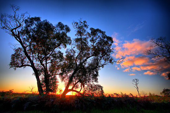
Gum trees growing precariously close to a cliff edge in western Victoria, Australia.
I was attracted to this scene by the trees silhouetted against the bright cloudy sky and of course the dead limbs in the foreground.

Home Sweet Hell
Images from an abandoned house taken during an excursion to the Dandenong Ranges, Victoria, Australia.

The image above is available to purchase as a print here.


Through the Fingal Forest
These images were taken on a recent excursion to Fingal beach, near Cape Schanck, Victoria, Australia.
The long track from the carpark to the beach is lined with twisted and gnarled trees creating an interesting viewing experience.
Visitors to the beach also experience the joy of navigating the hundreds of “awkwardly spaced” steps along the path. It’s not so bad going down to the beach but the return uphill journey is certainly a good test of your general fitness. Of course the ideal solution is to take along a strong, sturdy friend who can carry you back up the hill.
The images below were all taken using the Lumix LX3 camera.


After traversing the Fingal forest I managed to take this image.
Morning in the Forest of Ferns
Early morning in the forest of ferns.
As the sun rises higher in the sky, beams of sunlight break through the forest canopy spotlighting details in the foliage.
Glint


The Hope of the Green.
Surviving the devastating fires of last summer, fresh new growth springs from the charred base of a tree fern.
In the background, the blackened trunks of trees appear as dark vertical bands, many of them sprouting new lush green clusters of foliage.

Visiting Silverband Falls, the Grampians.
Image taken at the Silverband Falls, in the Grampians, Victoria, Australia.


Deep in the Woods
Fog blows across an otherwise sunny section of Mt.Difficult Road near Halls Gap, Australia.
This image is available as a quality print here.

Paradise Gully
Looking upstream at Cement Creek near Warburton, Victoria, Australia.
A beautiful lush green environment well worth visiting for it’s photo opportunities.
This image is available to purchase as a high quality print here.

Toorongo Falls – a view from the base
When no one was looking I climbed down off the official viewing platform and walked across a fallen tree trunk to capture this alternative view of the falls.
This image is available to purchase as a high quality print here.