
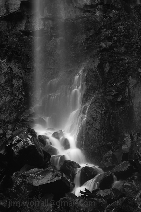
Sailors Falls
Sailors Falls is a beautiful spot just a few kilometres south of Daylesford on the Ballan-Daylesford Rd.
We were lucky enough to catch the falls with a decent flow of water going over the edge.
Return to Shack Bay and Eagles Nest
Shack Bay and Eagles Nest are part of the Bunurong Marine Park located between Cape Paterson and Inverloch. Access to the beach is via stairs from the cliff tops.
Pictured below – A long exposure image from Shack Bay with the Eagles Nest rock formation in the background.

Pictured below – The view from the end of Eagles Nest looking out to sea.

Pictured below – Shack Bay looking back towards Eagles Nest.

Storm at Powlett River
On the way back home from a recent excursion to Cape Liptrap we stopped off at the mouth of the Powlett River.
I had just enough time to catch this image before the rain started to pour down hard.

Marlo – Snowy River meets the Sea
A series of images from Marlo in Victoria where the mighty Snowy River meets Bass Strait.
The softening of the ocean waves in the background is achieved by the use of heavy ND filtering.


The Noojee – Toorongo Photo Trip
It was one of those spur of the moment decisions.
Chris and I took off for a leisurely drive intending to have lunch at the Noojee pub followed by an afternoon of shooting at the Noojee trestle bridge and the Toorongo River.
As it turned out things were very quiet in Noojee that Friday.
We entered the strangely vacant Noojee hotel dining room and spent a few minutes looking through the menu whilst hoping that they were actually open for business.
After a short time we were discovered by a helpful barmaid who ushered us into the bar area whilst explaining to us that the dining room was closed.
Pictured below – Dappled sunlight across the middle of the Noojee Trestle Bridge.

After being seated in the bar area Chris and I both chose the beer battered fish n’chips for lunch. Perhaps it wasn’t the most “heart smart” choice from the menu but it was indeed very tasty and satisfying without being too heavy. 🙂
As we ate our lunch Chris and I would occasionally glance over at the only other occupant of the room. One of the elderly locals was perched at the bar with beer in hand and kept nodding off to sleep. He appeared to be very skilled repeatedly awakening himself just prior to losing balance.
Pictured below – A shot taken from the top of the trestle bridge looking down on the access road. I’ve applied an Orton effect filter to this image to soften it a bit.

After finishing our delicious meals we visited the nearby Noojee trestle bridge. The light wasn’t particularly friendly that day as the morning clouds had dispersed causing a problem with harsh shadows and bright spots but we did our best.
Next stop was the wonderful Toorongo River. I always enjoy the scenic drive along the Toorongo Valley Road that leads to the falls.
It’s great to see the river with such a strong flow and healthy green mosses and small ferns growing on the moist rocks again.

During this trip I decided to try out the camera built into my phone and capture some images using an Android app called Retro Camera. It uses some interesting processing techniques to imitate old school cameras. A fun app!!
Pictured below – The Retro Camera interpretation of the Toorongo River.

Pictured below – A serene image from along the Toorongo Valley Road processed by the Retro Camera app.

Pictured below – Chris checking her shots on the banks of the river behind the Noojee pub.
Image processed by the Retro Camera app.

Construction at Powlett River
The construction of the controversial desalination plant near the mouth of the Powlett River has yielded a temporary point of interest for photographers.
A large platform has been placed offshore to assist with the construction of the required underwater pipeline.
Although not the most beautiful structure in the world, it acts as a nice point of interest for an otherwise potentially boring background.
I’m in no way a supporter of this project but I decided to take advantage of the platform while it’s there and took a series of images from the spot where the Powlett River meets the ocean.
The idea behind the images was to use the lines created by running water and rock edges to draw the viewer into the scene towards the platform in the background. The images were taken in bright mid afternoon light using strong ND filtering to enable the exposures to be long enough to blur the water.
Below – Platform One

Below – Platform Two

Below – Platform Three

Below – Mouth of the Powlett – Looking north-west across the mouth to the sand dunes, the waves crashing onto the rocks in the foreground just appear as mist due to the long exposure time.

Below – a couple of experimental panoramic shots of the river and dunes.


Visiting the Silky Lady – Hopetoun Falls
The Hopetoun Falls is a popular tourist attraction located in the Otway Ranges in Victoria, Australia.
Pictured below – A View to the Falls – Just a short distance from the car park, visitors are treated to a tempting glimpse of the falls from above through a gap in the lush forest greenery.

A short picturesque walk down a path through the forest gives access to the base of the falls. Upon arrival at the base it’s very easy to imagine that you’d somehow been transported into a fairytale. It’s a dream location for photographers and indeed it’s difficult to take a bad shot here.
Below – The Silky Lady

Below – Peeking at the Silky Lady

Below – In the Land of Fairytales

The Beauty of Polly McQuinn’s Weir, Strathbogie.
The picturesque Polly McQuinn’s Weir is well sign posted and located a few kilometers south-west of Strathbogie, Victoria, Australia.
The weir features a spillway where water streams over a concrete wall and onto large exposed granite boulders.
The water then continues snaking around more boulders before flowing under a road bridge then traversing a gently sloped granite plateau before reaching a deep pool surrounded by native vegetation.
There are many opportunities here for the keen photographer.
Below – A long exposure of water cascading over the spillway wall and onto granite boulders beneath.

Below – Looking back towards the spillway wall, water flows rapidly over and around granite boulders on it’s way downstream.

Below – In the days preceding my visit to the weir the area had received heavy rainfall.
I suspect this caused lot of the brown silt present in the water. This caused an interesting effect in the water with the deeper sections of the flow taking on a brownish tinge and the shallow sections appearing bluish during long exposure shots.

Below – The view from the bottom of the spillway looking downstream.
The silted water runs rapidly under the road bridge.

Below – “Polly’s Overflow” – Looking upstream from the pool, the water traverses a gentle granite plateau then strikes some foreground boulders whipping the water into a frenzy before it finally enters the tranquility of the pool. This image is available to buy as a print at my Zazzle and RedBubble sites.

Below – “In Search of Polly”
Apparently the weir was named after a young woman called Polly McQuinn who drowned here more than 100 years ago. Legend has it that the ghost of Polly can sometimes be heard calling for help from passer by.
Unfortunately I didn’t hear Polly on the day I was here.

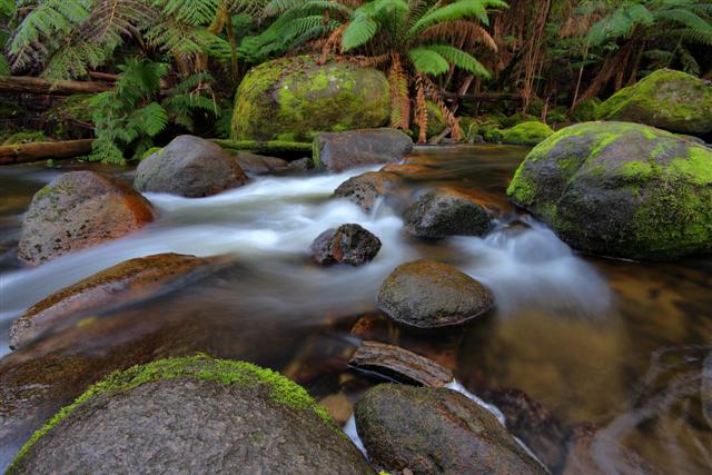
Exploring Cement Creek
It seems to me that Cement Creek was dealt an injustice when it was first named.
Despite it’s odd name, it really is quite an attractive location and a fine example of lush Victorian forest.
Cement Creek in located at the foot of Mount Donna Buang, near the intersection of Donna Buang Rd and Acheron Way.
On this excursion we gained access to the creek by walking along raised platforms which got us most of the way, then we jumped the handrail into the forest to get to the flowing water. At this location you need to be prepared to get muddy and wet, so it’s advisable to keep a change of clothes in the boot of your car.
The main hazard here is the slippery moss covered rocks. A minor hazard is the hungry leeches.


Burrabong meets the Bushranger
This image shows the Burrabong Creek meeting the ocean at Bushrangers Bay near Cape Schanck, Victoria.
Bushrangers Bay is a secluded beach located about one hours walk from the Cape Schanck car park.
The walking track winds it’s way through beach scrub, up and down hills including many stairs, and along scenic clifftops.
I would advise anyone taking this track to wear sturdy footwear as the path is shared with aggressive bull ants for much of the way, and of course there’s always a chance of encountering a snake sunning itself. Oh, and don’t forget a bottle of drinking water.

Roadside Falls
A small waterfall by the road somewhere south of Woods Point in hillbilly country, Victoria, Australia.
Roadside Falls

Milk of the Forest
An image taken from the Toorongo River near Noojee, Australia.

This is available to purchase as a high quality print here.
Paradise Gully
Looking upstream at Cement Creek near Warburton, Victoria, Australia.
A beautiful lush green environment well worth visiting for it’s photo opportunities.
This image is available to purchase as a high quality print here.

Dance of the Silken White
This image was taken from the banks of the Toorongo river, near Noojee, Australia.
It’s a wonderful lush place to visit, it’s only real downside being the local leeches.

This image is available to purchase as a high quality print here.
Toorongo Falls – a view from the base
When no one was looking I climbed down off the official viewing platform and walked across a fallen tree trunk to capture this alternative view of the falls.
This image is available to purchase as a high quality print here.

Serpent’s Haven – a nocturnal river scape

A nighttime river scape image taken at Port Douglas, Australia, using the Lumix LX3.
This image is available to purchase as a print here.
Exploring the magical Powlett River
A rewarding excursion to the beautiful mouth of the Powlett River.

Image above – The Rush of the Powlett.
Just prior to the Powlett’s water reaching the ocean, the shallow flow speeds up, rippling at the surface and dancing over low obstacles.
The dunes in the background and the river bank on the right glow yellow-orange as the sun sinks low on the horizon.
Image available for purchase here.

Image above – Ripples.
Evening at the mouth of the Powlett River.
The foreground rock and background dunes lit by the setting sun.
Image available for purchase here.

Image above – The Magic Hour.
The orange glow from the setting sun catches the tops of the foreground rocks and the distant dunes at the mouth of the Powlett River, Australia.
Image available for purchase here.

Image above – Looking towards the end of the Powlett River as it meets the ocean.

Image above – Last Rays at the Powlett.
Looking out across the river mouth to the setting sun.
Image available for purchase here.

Image above – Near Journeys End.
The Powlett River nears the end of it’s journey as it winds it’s way through sand dunes towards it’s ultimate destination, the ocean.
Image available for purchase here.

Image above – Powlett Sunset.
The sun sets as the Powlett River winds it’s way through the sand dunes.
Image available for purchase here.
Wet bum at the Toorongo Falls, Yarra Ranges National Park, Victoria, Australia.
The Toorongo Falls, in the Yarra Ranges National park, offers an excellent opportunity for those photographers who like to capture fast moving water over mossy green rocks. The dense foliage overhead provides low light conditions well suited to long exposures, giving that silky smooth appearance to the flowing water. Of course a tripod or beanbag is mandatory to stabilize the camera under these conditions.
The fun starts while trying to negotiate your way across the slippery logs and rocks to find the best vantage point for a shot. My advice for the serious tog would be to take along a spare pair of pants, or even better, a pair of fisherman’s waders. Both my friend and myself ended up with wet bums from unexpected sittings. Luckily my unreasonable fear of leeches remained under control. 😉
I’m definitely going to return to this site again in the future to explore it in more detail. The following three images from the Toorongo Falls area are available as prints from my Redbubble site at –
http://www.redbubble.com/people/pixelmuser
Title – Shivers of the Green.
Title – She ran.

Title – Toorongo Torrent.


