
The Trek to Bushrangers Bay Arch
There are two public walking tracks into Bushrangers Bay that are about the same length. One track starts north-east of the bay at Boneo Road and the other track begins at the Cape Schanck lighthouse carpark, west of the bay.
We chose to walk the track from the Cape Schanck lighthouse carpark because it’s arguably more scenic and there’s a lot more carpark spaces available.
Along the sandy track there’s a couple of opportunities to look back along the coastline towards Pulpit Rock.

Further along the track the native trees enclose the path and form a welcoming tunnel.


After a bit of walking the bush track crosses the Burrabong Creek via a small wooden footbridge. Eventually the bush track opens onto the sandy beach of Bushrangers Bay. Here you’ll encounter Main Creek which cuts through the sandy beach and enters the ocean.
You need to cross the creek. You might get wet feet here depending on how much water is flowing in the creek at the time, and how far you can jump. 🙂
In the photo below, Main Creek cuts through the sandy beach on it’s way to the ocean.

After crossing the creek it’s a short walk to the beautiful rock formations and platforms where at low tide there are lots of small crystal clear rock pools exposed.


At the water’s edge the rock platforms rumble as waves slam into the steep rocky walls.


Looking back from the arch towards Bushrangers Bay, lots of people exploring the platforms and rockpools.
It was a public holiday and very busy.


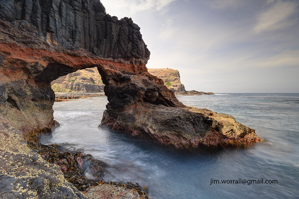
When we arrived at the arch we found that much of it was in the shade with very bright background elements.
This is problematic from a photography perspective, but anyway you work with what you’re given. 🙂

Photo below – Using a nice wide lens, some ND filtering, and blending 3 exposures I ended up with a keeper that I like.
This image is available to purchase as a print here.
The Beauty of Polly McQuinn’s Weir, Strathbogie.
The picturesque Polly McQuinn’s Weir is well sign posted and located a few kilometers south-west of Strathbogie, Victoria, Australia.
The weir features a spillway where water streams over a concrete wall and onto large exposed granite boulders.
The water then continues snaking around more boulders before flowing under a road bridge then traversing a gently sloped granite plateau before reaching a deep pool surrounded by native vegetation.
There are many opportunities here for the keen photographer.
Below – A long exposure of water cascading over the spillway wall and onto granite boulders beneath.

Below – Looking back towards the spillway wall, water flows rapidly over and around granite boulders on it’s way downstream.

Below – In the days preceding my visit to the weir the area had received heavy rainfall.
I suspect this caused lot of the brown silt present in the water. This caused an interesting effect in the water with the deeper sections of the flow taking on a brownish tinge and the shallow sections appearing bluish during long exposure shots.

Below – The view from the bottom of the spillway looking downstream.
The silted water runs rapidly under the road bridge.

Below – “Polly’s Overflow” – Looking upstream from the pool, the water traverses a gentle granite plateau then strikes some foreground boulders whipping the water into a frenzy before it finally enters the tranquility of the pool. This image is available to buy as a print at my Zazzle and RedBubble sites.

Below – “In Search of Polly”
Apparently the weir was named after a young woman called Polly McQuinn who drowned here more than 100 years ago. Legend has it that the ghost of Polly can sometimes be heard calling for help from passer by.
Unfortunately I didn’t hear Polly on the day I was here.


