


Seaford pier – Up before the dawn
Images from a pre-dawn trip to Seaford pier with friends from the ND400 Long Exposure group on Facebook. We arrived in the pitch black of early morning, ….a VERY unusual time for me, ….and waited for the sun to rise.

As the sun slowly rose behind us pastel colours appeared in the sky.

A long exposure image from under Seaford pier.

The morning was finished nicely with a civilized hot breakfast at the pier cafe. 🙂

Return to Mentone Groyne
A couple of long exposure images from the groyne on the beach at Mentone near the pub.


Tenby Point – West Jetty
A long exposure image at high tide from the picturesque shores of Tenby Point on Western Port Bay, Australia.


Cat Bay and Ventnor, Phillip Island long exposures
It was a fine day with fluffy white clouds scooting along on the breeze. It didn’t take long for me to convince myself to go down along the coast and play with some dark ND filters.
Below – The old jetty remnants at Cat Bay, Phillip Island.

Below – The old jetty remants at Cat Bay, Phillip Island.

Below – Summerlands beach, Phillip Island. I was lucky to catch this one with no footprints near it since this is a popular stretch of beach for the locals to wander on.

Below – Red Rocks beach, Ventnor, Phillip Island.

Below – Red Rocks beach, Ventnor, Phillip Island.

Below – Red Rocks beach, Ventnor, Phillip Island.

Below – Some old jetty remnants at Grantville beach, shot at dusk on the way home.

Tenby Point – The Jetty and the Mangroves
We had arrived just in time. The high tide was starting to recede giving us easy access to the beach yet there was still enough water covering the base of the jetty posts.
If you arrive at this destination at the wrong time you’ll find sticks in mud.
Below – Two images of the Tenby Point jetty remnants.


Pictured below – On the way back to the car park the water had receded enough to reveal the tangled root system on this Tenby Point icon.


A Sunset at Tooradin
A couple of images taken as the sun disappears below the horizon at Tooradin foreshore, Western Port Bay.
Pictured below – At high tide a mangrove sits semi submerged in the foreground as day gives way to night.

Below – A view from the Tooradin jetty looking back upstream towards town.

Catching the Instagram Train
The photography community seems to be polarized over the use of phone cameras and associated filter programs such as Instagram.
I must admit to being slow to travel down the “phone and filter” path and have only recently decided to give it a go to see what all the noise is about.
Since giving it a trial run I must admit that the use of Instagram and other similar programs has reintroduced a fresh and fun aspect to my photography.
Pictured below – Rye Pier.

I find it refreshingly simple to just pull out my phone, click, process and even publish the image so quickly.
I also enjoy being forced to rethink my compositions into a square format after being conditioned by years of using a 3×2 SLR format.
Pictured below – A foggy morning at Tooradin foreshore.

Admittedly I’ve had to resist the urge to “pixel peep” at the noise and visual anomalies created by some of the clunky filters.
This will never replace my SLR photography but I reckon it will complement it nicely. Phone photography has definitely introduced a fresh fun aspect to my photo life.
Pictured below – Mt Martha beach.

Cape Conran beach – the rockscapes and jetty
The beach at west Cape Conran offers an almost alien landscape populated with a huge array of highly eroded rocks. The jetty and boat ramp look out of place in this environment and so they tend to become the feature subjects of photographers who visit the site.
If you cant visit this site at sunset I’d recommend visiting during a day of high surf activity. The large waves crashing into these rocks create a really impressive scene.
I’m definitely going to revisit this location when I get the chance. There’s a lot to explore here.


A Stroll on Shelley beach – Portsea
A couple of images from a recent stroll on Shelley beach, Porstsea, Victoria.
It was one of those great days for photography. The clouds were very heavy causing a nice subdued light.
The threat of impending rain also meant I had the beach to myself, ……nice. 🙂


The Docking Station – Corinella
A high tide view of the docking station at Corinella. This is where the French Island barge docks to transfer vehicles and passengers to and from the mainland.

Below – Old Man of the Sea, an old mangrove tree just a stone’s throw away from the docking station.

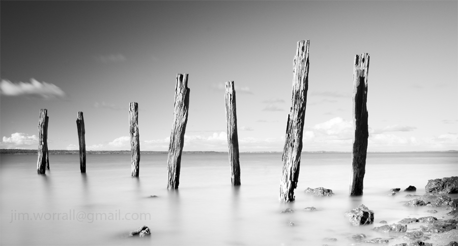
Exploring the Pointy End of Phillip Island
I’d been to this part of Phillip Island on previous occasions but I loved it so much I thought I’d revisit.
That’s one of the joys of photography, you can visit the same location on several occasions and come away with completely different images each time.
Pictured below – Old wooden remnants at Cat Bay, Phillip Island.


Pictured below – The beach at Right Point, Phillip Island, located between Cat Bay and the Nobbies. The violence of the ocean waves smoothed by the use of long exposure.


Snapshots from Tooradin
Tooradin is right at the top of my list when it comes to escaping for a little bit of quiet time. Located just a few minutes down the road from my home, Tooradin’s features include a serene creek that runs through the town and winds it’s way down to a great foreshore area where it joins with Westernport Bay.
The foreshore area usually has lots of parking spaces available and serves as a fine place to devour whatever delicacy you’ve chosen from the local bakery, fish and chip, or pizza shop.
Alternatively you can bring along your own boring food and make use of the BBQs.
Pictured below – The view looking down the channel towards Westernport Bay at low tide.

During low tide, large expanses of mud are exposed along both sides of the channel.
You can stroll along the elevated edge of the channel and watch as thousands of tiny crabs, disturbed by your presence, dive for cover into their tiny holes in the mud.
Pictured below – The view looking up the channel towards the main road.

Back to the serious topic of food for a moment, I highly recommend the Tooradin bakery with it’s fine selection of meat pies. They also have more sweet cake/bun/doughnut thingies than you could poke a stick at, …..and the coffee isn’t too bad there either.
The bakery is also conveniently located next to the fine Ice Cream shop, offering heaps of different flavours for those craving even more sugar. 😉
Fish n’chips must be big business in Tooradin because this tiny town has no less than two fish n chip shops.
On one side of the main road is the Tooradin Original Fish & Chip Shop and across the road is the Boardwalk Chippery. The Boardwalk shop boasts the use of “healthy rice bran oil”. The rice bran oil must be an acquired taste, …I’ve tried it but I haven’t yet acquired that particular taste,….but each to their own.
Pictured below – Down the channel a short distance, remnants of the old jetty pictured at high tide, complete with “god rays” shooting through the clouds signaling the end of a beautiful day.

Below – The same jetty remnants pictured at low tide, complete with an amazing number of mud dwelling crabs and their mud holes. 🙂

For the curious photographers who might be reading this post, the camera I used was a Panasonic Lumix LX3 in “dynamic B&W” mode with some minor corrections later in Photoshop.
If you’re interested in using any of these images or would like to purchase a high quality print then please contact me at – jim.worrall@gmail.com
What a Difference the Tide Makes.
A couple of images from the Flinders foreshore showing what a huge difference the tide can make.
Both images feature the same structure albeit from slightly different angles.
Below – Flinders Hombres – high tide at the jetty remnants.

Below – liN – the same jetty remnants at low tide.

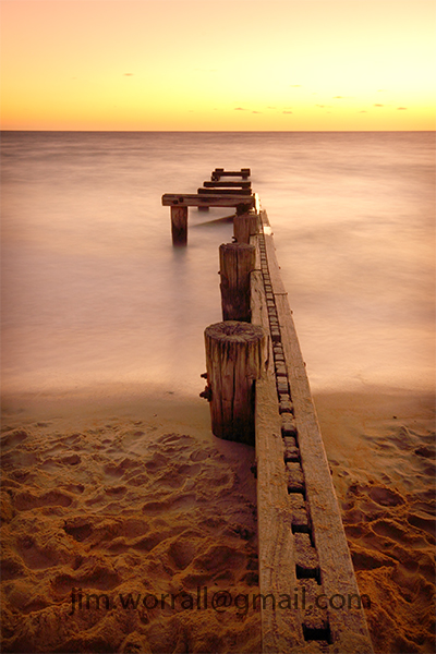
The Mentone Groyne
The Mentone groyne is located on Mentone beach just south of the Mentone pub. In the past this groyne has been incorrectly referred to as the “Old Mentone jetty” by myself and others. There’s off road parking close to the groyne but unfortunately the local council here tries to screw you over with a three dollar per hour parking fee.
All of the following images were taken using an ND400 filter to extend the exposure time and smooth out the waves on the water.
Below – Running West – Mentone Groyne

On the afternoon I visited the groyne it was almost high tide so these photos are only showing the very top bits of the structure above the water. Next time I visit I’ll be making sure I arrive during a low tide when the structure appears more like a series of small arches. I think that would be worth getting wet feet for. 🙂
Below – Charging into the Night.

Below – an overview of the groyne.

On the walk back to the carpark, some kind of territorial dispute erupted amongst these seagulls on a small rocky island just offshore. The image below doesn’t properly convey the ensuing ruckus but it was quite impressive to watch a little bit of nature’s drama playing out in front of me.
Below – Lord of the Gulls – ruckus on the rock.

Magic of the Phillip Island coastline.
Following on from previous posts I thought I’d share with you just a few more images from the Phillip Island coastline. I feel like I’ve just scratched the surface down there, …….there’s just so much beauty to explore and discover.
Pictured below – The Roost – old jetty remnants that serve as a safe roost for the local birds at Cat Bay.

Pictured below – Evidence of Life – a soft misty view of some wonderful wave action off Cowrie beach.

Pictured below – The Long Swim Home – another view from Cowrie beach looking towards the Nobbies in the background.

Pictured below – Pyramid Rock, taken in strong windy and wet conditions from a vantage point ahead of the lookout area.

In Lieu of Rapture
I’m dedicating this image to the recent passing of Rapture Day, May 2011.
Never has such a silly idea generated so much noise in the media and on social networks.
Pictured below – In Lieu of Rapture.

The image was captured at Cat Bay on Phillip Island.
The bollard, the boat, the buoy and the beginning of a rainbow.
Saturday’s excursion was down towards the pointy end of the Mornington Peninsula.
After a hearty lunch of fish ‘n chips on Dromana beach, it was off to Sorrento for a cappuccino and also check out the surf conditions on the ocean side.
On arrival at the back-beach the surf was violent and unruly, fueled by a ferocious onshore wind.
I’ve tried to capture long exposure images under these conditions a couple of times before and come away from the experience with disappointing results. A howling wind always manages to soften my long exposure images regardless of tripod technique.
With this in mind I resigned myself to exploring the calmer more docile side of Sorrento, the bay side. The view from the beach here was quite nice with small boats bobbing and wobbling around in the water. I took a few shots of the little boats but couldn’t find anything particularly satisfying so I moved my attention to the huge bollards near the pier.
Pictured below – Bollard.

Above – In this image the huge concrete bollard remains motionless whilst surrounded by the blurred movement of waves on the water. It’s nearby neighbors, the boat and the buoy wobble and rock in compliance with the waves. I used a high key effect to eliminate some distracting elements from the background. Both ND400 and ND8 neutral density filters were attached to the lens to achieve the desired long exposure under fairly bright conditions.
Pictured below – The Sorrento Bollards.

Above – The massive bollards are used to assist with holding the Queenscliff-Sorrento ferry in place at the pier during the exchange of passengers and cars.
After shooting the bollards, mother nature tried to grow me a rainbow. The left and right ends of the rainbow were developing nicely and gradually growing skywards then suddenly fizzled into nothingness.
Pictured below – the left end of the incomplete rainbow.

Pictured below – the right end of the incomplete rainbow.

By the Seaside – Tooradin and Corinella
Following are some images from the shores of Westernport Bay.
Pictured below – The Journey Home, seagulls at the Tooradin foreshore take off en masse as the day gives way to night.

Below – Corinella Sunset, a series of “God beams” appear from behind a cloud as the sun sets at Corinella pier. These “God beams” are also known as crepuscular rays and are explained at Wikipedia here.

Below – The Living Jetty.
At Corinella a jetty platform disappears below the surface during a king tide.
The local sea birds take advantage of the exposed posts by using them as a safe roost.

Below – The best position for overseeing the activities at the Corinella jetty area.

A King Tide at Grantville
My initial plan was to stop at Grantville, visit the bakery for a mandatory steak pie and cappuccino, then take a long stroll along the beach.
The consumption of the pie and cappuccino went nicely to plan. On arrival at the beach all that had changed.
Where’s the beach gone? ………….
I had apparently arrived at the peak of a king tide. There was no sand to be seen anywhere, much less walk along.
Pictured below – looking out towards the jetty the fishermen appeared to be almost walking on water. It was unusual to see the water lapping across the platform on the lower section of the jetty.

Luckily there aren’t many jumping sharks in Westernport Bay!

Pictured below – A few images from along the beach, north of the jetty, taken with a Lumix LX3 camera.
It’s amazing how salt tolerant these trees can be.


Where’s my sandy beach gone?
Due to the king tide, navigating the coast required walking through low lying vegetation, and it didn’t feel right. 😦


I should check my tide charts more often.
If you’re interested in buying any of these images as prints then please contact me at – jim.worrall@gmail.com
Exploring the light at Right Point, Phillip Island
Saturday’s excursion to Phillip Island turned out to be very rewarding from a photographer’s perspective.
In the late afternoon I stopped at a place called Right Point, which seems to be a very popular destination for surfers. As I peered over the edge of the cliff towards the beach I instantly fell in love with this spot.
Below me were the remains of an old jetty being pounded by the violent surf.
With the sun starting to drop towards the horizon what more could a photographer ask for?
I grabbed my tripod and camera bag and dashed down to the beach like an excited child. The images were already forming in my mind before I had even reached the sand, ……..oh what a feeling !! 🙂
Below – Drawn to the Ocean

Below – The Penguin Pool

As the sun dropped even closer to the horizon a good situation became even better when suddenly Crepuscular rays broke through a gap in the clouds.
Crepuscular rays, also known as “God rays” or “God beams” are explained here.
Below – Running to the Light

Below – Sky Burst

Below – Agaze

The Flinders Pier Excursion.
Images from a recent trip to Flinders with friends Christine Wilson and Caroline Gorka.
The objective for the afternoon was to capture some images of the old wooden pier before it’s replaced by the concrete monster that’s currently being constructed right next to it.
As usual I became distracted.
Below – “IiN” some ghostly remains from further along the beach.


Below – “Flinders Point” just around the corner from the calm harbor area there’s a lot more ocean wave activity.
There were waves crashing all over the place here but the long exposure makes it look deceptively calm.

Below – “Flinders Back-Beach” near the blow hole area. Stop giggling, that’s what it’s called !!


The Window of Opportunity – Grantville Beach.
Amongst the photographic gems that Grantville beach makes available to photographers is a set of 3 rows of short pylons.
No doubt these pylons are the remains of an old jetty but they differentiate themselves from other such sites in a couple of interesting ways. Firstly, it’s unusual to see 3 rows of pylons like this. Most old jetties leave behind only two rows of pylons.
Secondly the pylons are extremely short here, with most of them extending from the muddy base by only a few short inches.
The short stature of these pylons provides photographers with an interesting challenge. At high tide the pylons are invisible as they’re completely submerged by water, and at low tide they’re an awful looking series of posts sitting in mud.
The challenge for the photographer is to arrive at the site during a narrow window of opportunity whilst the tidal transition ideally has all of the pylons surrounded by water around their bases and yet not enough water to make them shorten or disappear below the surface.
Below – “Runway to the Afterlife”

On my first visit to the site I was extremely lucky and caught the tide at just the right height. I wasn’t aware of how elusive these pylons could be until subsequent visits, hoping to catch the pylons in a different light, I haven’t been fortunate enough to arrive at the right time. 😦
Below – “Mortality” an image taken near the pylons on a different evening. The dark brooding sky sets the mood of the image. In the foreground lays a dead jellyfish, stranded by the outgoing tide.

Below – “Deep Creek Reflections“, also near the pylons Deep Creek enters the Westernport Bay.

Trolling around under bridges and piers
On excursions where I’m near a bridge or pier, my inner troll has a tendency to take control and drag me under.
Sometimes the results are quite pleasing. Strangely enough I often find the underside to be more photographically pleasing than the top side.
Below – “Gateway” the underside of the San Remo bridge.

Below – “San Remo Bridge” the gateway to Phillip Island, Victoria, Australia.

Below – “Dromana Downunder” the underside of Dromana pier. No trolls under here!

A Photo Exploration of Grantville beach.
I visited Grantville the day after Victoria had been hammered by unusually high rainfall.
Apparently the extreme rainfall was a side effect of cyclone Yasi’s passage across Queensland and into central Australia.
With the worst of the rain over, the day provided some beautiful photographic conditions with the sun filtered through an interesting arrangement of constantly changing storm clouds.
I love the beach down this way. Each time I visit here I discover something new.
Before I discovered photography I would never have guessed that I would find storm water drains interesting. 🙂
Below – “Purge” a storm water drain running into Westernport Bay.

For those who are interested in the technical details, the drain images are constructed using HDR tone mapping techniques. The long exposures were achieved using a combination of ND400 and ND8 filters on the end of the lens to smooth the waves on the water.
Below – “Running from the Idols” – another drain dumping water into Westernport Bay.

Below – A long exposure self portrait, standing at the end of the Grantville jetty.

Below – “Grantville Jetty” – a view from the jetty looking out towards the boat ramp marker posts.

Below – “After the Rains” – a long exposure image from Grantville beach as rain clouds exit. An old boat trailer sits semi-submerged in the foreground.


