
Ol’ Woody at Tenby Point
Ol’Woody is a popular mangrove tree at Tenby Point on Western Port Bay.
In this image the reflection in the water has been enhanced by smoothing the surface ripples using a 180 second exposure time made possible with dark ND filters.


The Gateway – Coronet Bay
Using the ND400 filter to obtain a ten second exposure during the afternoon at Coronet Bay, Victoria, Australia.

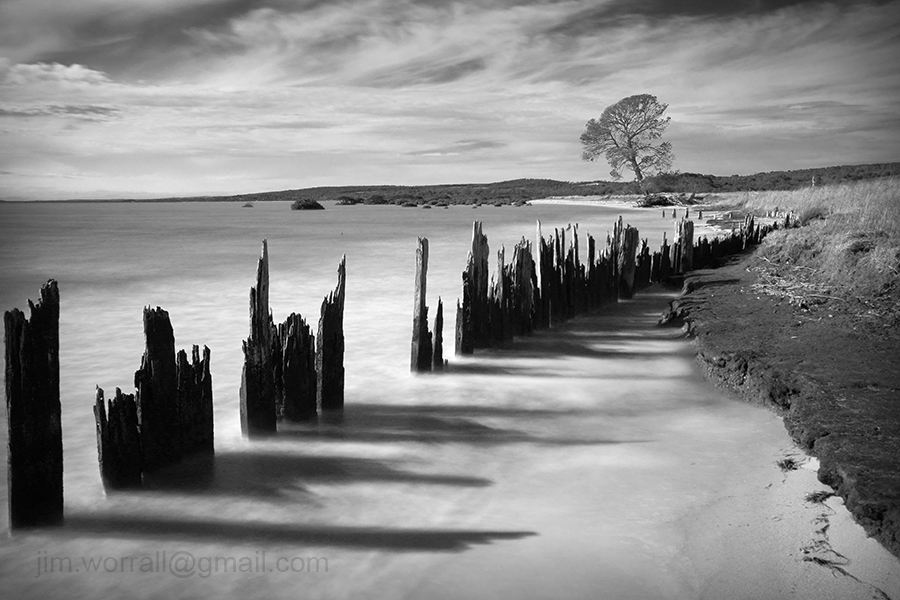
Old Sea Wall – Queensferry
A long exposure image from the beach at Queensferry, Western Port Bay.

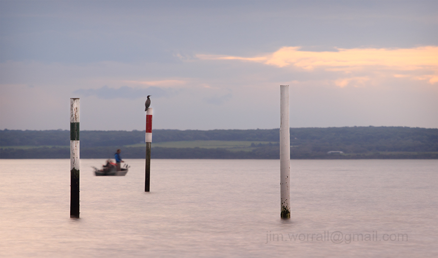
Tenby Point – West Jetty
A long exposure image at high tide from the picturesque shores of Tenby Point on Western Port Bay, Australia.


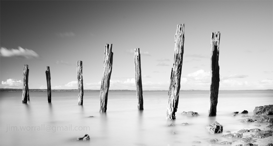
Cat Bay and Ventnor, Phillip Island long exposures
It was a fine day with fluffy white clouds scooting along on the breeze. It didn’t take long for me to convince myself to go down along the coast and play with some dark ND filters.
Below – The old jetty remnants at Cat Bay, Phillip Island.

Below – The old jetty remants at Cat Bay, Phillip Island.

Below – Summerlands beach, Phillip Island. I was lucky to catch this one with no footprints near it since this is a popular stretch of beach for the locals to wander on.

Below – Red Rocks beach, Ventnor, Phillip Island.

Below – Red Rocks beach, Ventnor, Phillip Island.

Below – Red Rocks beach, Ventnor, Phillip Island.

Below – Some old jetty remnants at Grantville beach, shot at dusk on the way home.

Balnarring Beach Groynes
The groynes at Balnarring Beach serve to reduce erosion at the water’s edge. Most of the groynes are simply a line of posts connected together by planks creating a straight sea wall.
I was struggling to find something interesting on the beach then stumbled across this baby zig-zagging out into the bay.

Below – The usual straight groyne.

Below – The making of Zig Zag.

Tenby Point – The Jetty and the Mangroves
We had arrived just in time. The high tide was starting to recede giving us easy access to the beach yet there was still enough water covering the base of the jetty posts.
If you arrive at this destination at the wrong time you’ll find sticks in mud.
Below – Two images of the Tenby Point jetty remnants.


Pictured below – On the way back to the car park the water had receded enough to reveal the tangled root system on this Tenby Point icon.


Catching the Instagram Train
The photography community seems to be polarized over the use of phone cameras and associated filter programs such as Instagram.
I must admit to being slow to travel down the “phone and filter” path and have only recently decided to give it a go to see what all the noise is about.
Since giving it a trial run I must admit that the use of Instagram and other similar programs has reintroduced a fresh and fun aspect to my photography.
Pictured below – Rye Pier.

I find it refreshingly simple to just pull out my phone, click, process and even publish the image so quickly.
I also enjoy being forced to rethink my compositions into a square format after being conditioned by years of using a 3×2 SLR format.
Pictured below – A foggy morning at Tooradin foreshore.

Admittedly I’ve had to resist the urge to “pixel peep” at the noise and visual anomalies created by some of the clunky filters.
This will never replace my SLR photography but I reckon it will complement it nicely. Phone photography has definitely introduced a fresh fun aspect to my photo life.
Pictured below – Mt Martha beach.

Queensferry – a contrast of tides
Following are a series of images from Queensferry, on Western Port Bay, demonstrating the area’s vast difference in appearance between high tide and low tide. The high tide images were taken using my 40D with heavy ND filtering.
The low tide images were captured a week earlier (as reference photos) using my phone camera and post processed using an Android app called Retro Camera.
Red Bricks 146


The Docking Station – Corinella
A high tide view of the docking station at Corinella. This is where the French Island barge docks to transfer vehicles and passengers to and from the mainland.

Below – Old Man of the Sea, an old mangrove tree just a stone’s throw away from the docking station.

Tenby Point Revisited
There’s something quite magical about Tenby Point. It’s one of those areas I feel compelled to visit from time to time.
A great surprise this visit was to find the road is now surfaced with asphalt. I’m going to miss all the corrugations and pot holes that once adorned the old dirt track leading to the beach.


Snapshots from Tooradin
Tooradin is right at the top of my list when it comes to escaping for a little bit of quiet time. Located just a few minutes down the road from my home, Tooradin’s features include a serene creek that runs through the town and winds it’s way down to a great foreshore area where it joins with Westernport Bay.
The foreshore area usually has lots of parking spaces available and serves as a fine place to devour whatever delicacy you’ve chosen from the local bakery, fish and chip, or pizza shop.
Alternatively you can bring along your own boring food and make use of the BBQs.
Pictured below – The view looking down the channel towards Westernport Bay at low tide.

During low tide, large expanses of mud are exposed along both sides of the channel.
You can stroll along the elevated edge of the channel and watch as thousands of tiny crabs, disturbed by your presence, dive for cover into their tiny holes in the mud.
Pictured below – The view looking up the channel towards the main road.

Back to the serious topic of food for a moment, I highly recommend the Tooradin bakery with it’s fine selection of meat pies. They also have more sweet cake/bun/doughnut thingies than you could poke a stick at, …..and the coffee isn’t too bad there either.
The bakery is also conveniently located next to the fine Ice Cream shop, offering heaps of different flavours for those craving even more sugar. 😉
Fish n’chips must be big business in Tooradin because this tiny town has no less than two fish n chip shops.
On one side of the main road is the Tooradin Original Fish & Chip Shop and across the road is the Boardwalk Chippery. The Boardwalk shop boasts the use of “healthy rice bran oil”. The rice bran oil must be an acquired taste, …I’ve tried it but I haven’t yet acquired that particular taste,….but each to their own.
Pictured below – Down the channel a short distance, remnants of the old jetty pictured at high tide, complete with “god rays” shooting through the clouds signaling the end of a beautiful day.

Below – The same jetty remnants pictured at low tide, complete with an amazing number of mud dwelling crabs and their mud holes. 🙂

For the curious photographers who might be reading this post, the camera I used was a Panasonic Lumix LX3 in “dynamic B&W” mode with some minor corrections later in Photoshop.
If you’re interested in using any of these images or would like to purchase a high quality print then please contact me at – jim.worrall@gmail.com
Magic of the Phillip Island coastline.
Following on from previous posts I thought I’d share with you just a few more images from the Phillip Island coastline. I feel like I’ve just scratched the surface down there, …….there’s just so much beauty to explore and discover.
Pictured below – The Roost – old jetty remnants that serve as a safe roost for the local birds at Cat Bay.

Pictured below – Evidence of Life – a soft misty view of some wonderful wave action off Cowrie beach.

Pictured below – The Long Swim Home – another view from Cowrie beach looking towards the Nobbies in the background.

Pictured below – Pyramid Rock, taken in strong windy and wet conditions from a vantage point ahead of the lookout area.

In Lieu of Rapture
I’m dedicating this image to the recent passing of Rapture Day, May 2011.
Never has such a silly idea generated so much noise in the media and on social networks.
Pictured below – In Lieu of Rapture.

The image was captured at Cat Bay on Phillip Island.
A Trip to the Pointy End – Phillip Island
Over the weekend I did a quick reconnaissance trip down to the pointy end of Phillip Island.
The images below were taken on a stretch of unsealed road named “The Boulevard” which runs along the south coast of Summerlands and ends at the Nobbies. The Boulevard is a grand name indeed for what amounts to a narrow dirt track, however the coastal views can be quite impressive from here.
Pictured below – The view from The Boulevard looking west towards the Nobbies.

Unfortunately for those of us who like to immerse ourselves in these kinds of coastal environments there is no beach access permitted. We’re reminded of this fact by strategically placed signs warning of penalties for such breaches.
Pictured below – The view from The Boulevard looking east.

Pictured below – a zoomed in view of the coastline. It looks like a fine place for a photographer to play.

When finished with the south coast I made the short trip over to the north coast to visit Cowrie beach. I’ve been here once before but I had some unresolved images in my head that I wanted to try to capture here. Most of the northern coast is photographer friendly, allowing one to get as close to the water as one dares.
Pictured below – Bull in a China Shop, one of the less sedate Phillip Island waves attacking from left of frame.

Pictured below – A long exposure image using an ND400 filter, The Course of the Penguin, one of the many corridors used by the penguins of Phillip Island.

After finishing at Cowrie beach I left the island and crossed the bridge over to San Remo on the mainland. As I was crossing the bridge I noticed some amusing looking stairs below, surrounded entirely by the water of a high tide. It appeared to be a stairway going from nowhere to nowhere.
Pictured below – From Nowhere to Nowhere, San Remo.

The day concluded with a delicious meal of fish n’ chips from the Fisherman’s Cooperative, …..what bliss!
Downtime – a relaxing afternoon at Warneet
I have mixed feelings about the changes being made to the coastal village of Warneet.
Many of the grand old pine trees along the beachfront have been cut down and it appears that the main dirt roads are being surfaced. Progress, …..I guess.
Pictured below – Downtime – An iconic landmark (watermark) at Warneet coastal reserve.

Pictured below – some of the locals.


By the Seaside – Tooradin and Corinella
Following are some images from the shores of Westernport Bay.
Pictured below – The Journey Home, seagulls at the Tooradin foreshore take off en masse as the day gives way to night.

Below – Corinella Sunset, a series of “God beams” appear from behind a cloud as the sun sets at Corinella pier. These “God beams” are also known as crepuscular rays and are explained at Wikipedia here.

Below – The Living Jetty.
At Corinella a jetty platform disappears below the surface during a king tide.
The local sea birds take advantage of the exposed posts by using them as a safe roost.

Below – The best position for overseeing the activities at the Corinella jetty area.

A King Tide at Grantville
My initial plan was to stop at Grantville, visit the bakery for a mandatory steak pie and cappuccino, then take a long stroll along the beach.
The consumption of the pie and cappuccino went nicely to plan. On arrival at the beach all that had changed.
Where’s the beach gone? ………….
I had apparently arrived at the peak of a king tide. There was no sand to be seen anywhere, much less walk along.
Pictured below – looking out towards the jetty the fishermen appeared to be almost walking on water. It was unusual to see the water lapping across the platform on the lower section of the jetty.

Luckily there aren’t many jumping sharks in Westernport Bay!

Pictured below – A few images from along the beach, north of the jetty, taken with a Lumix LX3 camera.
It’s amazing how salt tolerant these trees can be.


Where’s my sandy beach gone?
Due to the king tide, navigating the coast required walking through low lying vegetation, and it didn’t feel right. 😦


I should check my tide charts more often.
If you’re interested in buying any of these images as prints then please contact me at – jim.worrall@gmail.com
An Afternoon at Cowrie Beach, Phillip Island.
Cowrie Beach is located just a few hundred meters north-east of the popular tourist destination “The Nobbies” on Phillip Island, Australia. The beach sits just inside the entrance to Westernport Bay and is subjected to rough surf originating from Bass Strait.
The thinly vegetated sandy portions of the beach are home to Fairy penguins and some other more endangered species so there are signs present advising which areas to avoid.
The main attraction here from my perspective is at the water’s edge. The beach is blessed by the presence of dark basalt rock formations continuously pounded by waves.
Below – The Nobbies – an image from Cowrie beach with The Nobbies in the background.

Below – Down the Winding Path – a long exposure looking out to sea from Cowrie Beach.

Below – Awaiting the Devil – a frightening part of the beach where unexpected waves suddenly inundate the dark basalt platforms. There’s a warning sign on the beach reminding fishermen and other visitors how easy it is to be swept off these rocks.

Below – The Ordeal – How the Phillip Island penguins manage to survive the violent Bass Strait surf combined with rocky beaches escapes me.

Below – Through the Vapour

Contrasts – Views from Jam Jerrup
Contrasting views from the beach at Jam Jerrup, Victoria, Australia.
It’s interesting to see how different a location can appear under different light and tidal conditions. This is exactly the reason why I like to return to the same places many times.
Below – “Aspirations” is a minimalistic long exposure image taken at high tide.

Below – “Blunderbuss” is a wider view of the same area taken at low tide with some more drama taking place in the clouds.

Below – “Exploring the Meme” is the boat ramp and single post at Jam Jerrup.

A Photo Exploration of Grantville beach.
I visited Grantville the day after Victoria had been hammered by unusually high rainfall.
Apparently the extreme rainfall was a side effect of cyclone Yasi’s passage across Queensland and into central Australia.
With the worst of the rain over, the day provided some beautiful photographic conditions with the sun filtered through an interesting arrangement of constantly changing storm clouds.
I love the beach down this way. Each time I visit here I discover something new.
Before I discovered photography I would never have guessed that I would find storm water drains interesting. 🙂
Below – “Purge” a storm water drain running into Westernport Bay.

For those who are interested in the technical details, the drain images are constructed using HDR tone mapping techniques. The long exposures were achieved using a combination of ND400 and ND8 filters on the end of the lens to smooth the waves on the water.
Below – “Running from the Idols” – another drain dumping water into Westernport Bay.

Below – A long exposure self portrait, standing at the end of the Grantville jetty.

Below – “Grantville Jetty” – a view from the jetty looking out towards the boat ramp marker posts.

Below – “After the Rains” – a long exposure image from Grantville beach as rain clouds exit. An old boat trailer sits semi-submerged in the foreground.

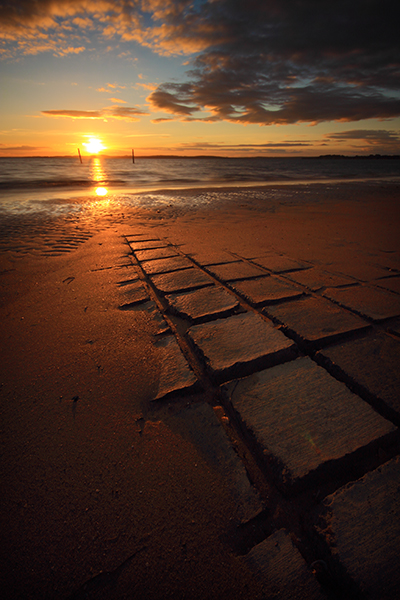
A Photographic Trip to Tenby Point.
Tenby Point is a coastal village located on the shores of Westernport Bay, just a few kilometers east of Corinella, Victoria, Australia.
On this particular photography excursion conditions weren’t ideal. The sun was harsh and high in the sky, and there were no clouds around. Due to these harsh light conditions I chose to make a series of high key images whilst the tide was favorable.
Below – The Counsel of Many

It’s important to know what the tides are doing here from a photographer’s prespective.
I think it’s best here to avoid visiting at low tide unless you’d like images of sticks or trees sitting in mud.
The black and white images in this post were taken with both an ND400 and an ND8 filter attached to the end of the lens to achieve long exposure times in bright sunny conditions. The goal behind using such heavy filtering is to achieve long exposure times in order to blur as much detail as possible from the sky and water.
The result is a more minimalistic image.
Below – Sweet Survivor

Below – The Path to Yesterday

Eventually all good things come to those who wait. The afternoon dominated by harsh white light gave way to a pearler of a sunset when some clouds moved across the sky at just the right moment. I drove home from Tenby Point wearing a satisfied grin. 🙂
Below – Sunset at Tenby Point

Slowly submerging in Tooradin
The coastal village of Tooradin is located on the shores of Westernport Bay, Victoria, Australia.
Since I live fairly close to Tooradin I often pick up a hot pie and a cappuccino from the wonderful bakery here and drive down to the jetty area for a relaxing break.
Tooradin has two jetties right next to each other. One jetty is of a floating pontoon design which rides on the surface of the water, rising and falling as the tides change. The other jetty is the usual kind consisting of a raised platform fixed to sturdy wooden pillars.
An interesting thing about the fixed platform jetty is that the platform gradually disappears below the surface of the water as the tide rises. This provides the photographer with some interesting possibilities.
Below – the rising tide starts to envelope the platform.

Standing on this jetty makes one feel like a captain going down with his ship.
Below – “Channel” which is available to purchase as a print here.
The platform is just a few centimeters below the surface.

After taking a few long exposures at the jetty mother nature decided to give me a nudge. The thick black storm clouds opened up and sent down a barrage of hail to chase me back to the car.
Below – Run from the Hail

Down amongst the Mangroves, Westernport Bay.
You certainly have to admire the hardiness of the Mangrove tree.
It thrives in poor quality soil in tidal areas, and twice a day has it’s roots submerged in salty sea water. Under storm conditions the Mangrove is battered by both wind and waves yet it still manages to hold firmly.
The Mangrove tree is also an interesting subject from a photographer’s perspective. At high tide with the roots submerged it’s fairly easy to photographically isolate the subject from it’s surroundings by using a long exposure time to smooth any waves around it’s base and blur any clouds in the sky.
Below – TimeKeeper

Below – The Risen

Below – Approaching the Forest

At low tide the Mangrove tree has it’s roots exposed creating potentially a new subject of interest for the photographer. The long roots are often intertwined with each other giving the impression of writhing serpents (perhaps that’s just my imagination running wild).
Below – The Serpent Tree

Below – Wild n’ Woolly a long exposure with the roots exposed and the leaves thrashing around in the wind.

Below – On Borrowed Time the same tree as above but at high tide.

Swanning around Westernport Bay
Here are some more images taken at various places around Westernport Bay, Victoria, Australia.
It’s always a lot of fun shooting around here at low tide. The beaches feature a fine grain sticky mud that slowly tries to draw you beneath the surface. With each step that you take you risk losing your footwear. 🙂
Taking long exposures is certainly interesting as the tripod gradually sinks into the silt.
This is just the sort of place where you should take emergency pants in case you unexpectedly sit down in the mud.
The following image was taken at Crib Point beach.

This image Barnacle Build was shot at Balnarring beach.

The following image The Threat of Punishment was taken at Grantville beach. All of the ground in this shot is mud.


